Welcome to Wistaston & Willaston
Wistaston & Willaston is a brand new ward created following the Cheshire East boundary review, covering two of South Cheshire’s most cherished villages. The ward is home to approximately 8,000 residents on the south-western edge of Crewe, part of the Crewe & Nantwich constituency.
The ward brings together the village of Wistaston — with its historic St Mary the Virgin Church, Valley Brook, Wistaston Green and thriving community — and the neighbouring village of Willaston, known for its beautiful village green, iconic red telephone box community book exchange, and strong rural Cheshire identity.
Roger and David are your Conservative candidates for this ward, committed to protecting the Green Gap, fixing our roads and keeping our community safe.
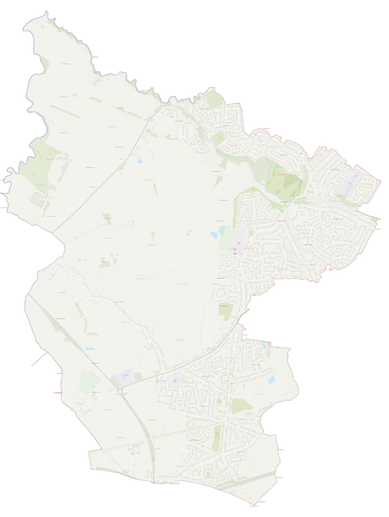
Map of Wistaston & Willaston Ward. Boundary effective from the 2027 Cheshire East elections per The Cheshire East (Electoral Changes) Order 2026.
📄 Download a detailed PDF map of the wardHow to Get in Touch
Roger and David want to hear from residents across Wistaston and Willaston. Whether it’s a pothole, a planning concern, an issue with antisocial behaviour, or something else entirely — please get in touch.
📞 Visit our contact page to send a message or fill in the contact form. Not a resident of Wistaston & Willaston? You can still find your local councillor at WriteToThem.
Am I in the Wistaston & Willaston Ward?
Here is a list of residential roads within the Wistaston & Willaston ward. If your street appears below, Roger Morris and David Simcox are your Conservative candidates for this ward.
| Abbey Fields | Addison Close |
| Alvaston Walk | Ambleside Close |
| Arundel Close | Beaumont Close |
| Beech Drive | Blake Close |
| Borrowdale Close | Bowness Road |
| Braemar Close | Brereton Close |
| Brookland Avenue | Broughton Lane |
| Brydson Crescent | Buckingham Close |
| Buckley Avenue | Byron Way |
| Caernarvon Road | Carisbrook Close |
| Carroll Drive | Chesterton Drive |
| Christchurch Avenue | Church Lane |
| Church View Walk | Clare Drive |
| Cob Road | College Fields |
| Corbetts Close | Cowper Close |
| Crewe Road (A534) | Cygnet Drive |
| Dappleheath Road | Drake Place |
| Dryden Close | Edinburgh Road |
| Elm Close | Fairbrook |
| Field Avenue | Field Lane |
| Gadwall Close | Glamis Close |
| Glendale Close | Grebe Drive |
| Hardy Close | Harrow Close |
| Hawthorn Lane | Herrick Close |
| Holyrood Drive | Keats Drive |
| Kings Drive | Laburnum Avenue |
| Langdale Road | Larch Road |
| Laurel Drive | Lear Drive |
| Lydgate Close | Magdalen Court |
| Mandarin Place | Manor Avenue |
| Marlborough Close | Marlowe Close |
| Marys Gate | Meynell Close |
| Middlewich Road (A530) | Milne Close |
| Milton Drive | Minster Court |
| Mulberry Road | Nessina Grove |
| Park Drive | Patterdale Close |
| Pen Road | Pochard Close |
| Princess Close | Princess Drive |
| Princess Grove | Prior Close |
| Rectory Close | Riverside Grove |
| Sandhurst Avenue | Sandringham Drive |
| Shelley Drive | Shoveler Close |
| Spencer Close | Strathaven Avenue |
| Swift Close | Tatton Road |
| Taylor Road | Teal Way |
| Tennyson Close | Thirlmere Road |
| Thorley Grove | Trinity Close |
| Valley Road | Waldron Gardens |
| Westfield Drive | White Hart Lane |
| Wigeon Road | Willow Crescent |
| Windermere Road | Windsor Road |
| Wistaston Avenue | Wistaston Green Road |
| Wistaston Park | Wistaston Road |
| Woodford Close | Woodside Avenue |
| Woodside Lane | Wordsworth Close |
| Yew Tree Road |
| Bannacks Close | Basset Close |
| Bayley Road | Beech Tree Close |
| Brassey Way | Cedar Court |
| Colleys Lane | Coppice Road |
| Crewe Road | Eastern Road |
| Gladstone Street | Highfields Road |
| Holly Drive | Magpie Lane |
| Meadow View | Moorfields |
| Orchard Street | Park Mills Close |
| Park Road | Tricketts Lane |
| Wistaston Road | Wybunbury Road |
* Willaston street list pending confirmation from Cheshire East Electoral Services. If your street is missing please contact us.